


Terania Keerrong Flood Safety Project
Convenors:
Annie Kia
Email: Annie Kia
How It Works
We started this project when we discovered serious problems with the flood monitoring system in 2022. Diggin deeper, we saw these problems were longstanding, and realised that there had never been comprehensive flood warnings for people at The Channon and Keerrong valley. During the megaflood of February 2022, upstream residents were distressed that they could not convey the risk to those downstream. We knew local knowledge was needed, so we decided to create our own system of citizen flood intelligence. Initially we called it The People’s Catchment, but then we realised we needed to make it clear that the scale of the project was the Terania subcatchment. After that we called it the Terania-Keerrong Flood Safety project. It is a work in progress and we are always learning.
Rain Sentinels
We understand the value of experienced, reliable informants, and established a network of 10 people willing to make frequent observations during events. This network covers the headwaters of Tuntable, Terania, Branch and Rocky Creeks. We don’t need large numbers of people reporting – just have key locations covered. When an event starts, we ‘switch on’ certain rain sentinel locations, asking them to make frequent observations on a Heavy Rainfall Chart to provide precipitation rates. The observation interval may be every 2 hours. If a particular rain sentinel is not available, we ask another person at that location if they’d do it. We are currently working to improve back-up communications for when the phone and internet fail. Our terrain is lumpy and dissected and we’ve found CB (UHF) radio does not reach our distant sentinels, so now we are shifting to 27MHz radios for four of these sentinel locations. These are not installed yet. We will also install additional automatic weather stations that people will be able to see on Wunderground platform – see Your Sources of Flood Information
Our Collaboration With The SES
We have an agreement with the SES to provide them with data on Terania catchment rain and creeks. If they judge the situation dangerous, they will issue warnings for The Channon and Keerrong valley, using their new warning system. Two things are new here. Firstly, the SES has new powers to issue warnings for rural areas. Previously they only issued specific warnings for river towns like Lismore. Secondly, there has never been comprehensive catchment data that could inform such a warning. Our community is stepping up to provide that data.
How This Worked In October 2022 – A Test
When an event starts we contact members of our CB Radio network and ask them to switch on their CB radios. We also ask Rain Sentinels to start making observations. The October rain event did not turn out to be as intense as first predicted, and was a great opportunity to test our system. During this event we collated data from Rain Sentinels at Whian Whian, Terania, Tuntable Falls and The Channon, and shared the collated data with the SES. We also sent an email summary of the rain data to members of our CB radio network. We sent a bulk SMS to tell them to read their email, and did a CB radio broadcast to suggest the same. It is important to note that we cannot issue flood warnings – only the SES can do this. But we can certainly share catchment data to those downstream, to help their situation awareness. In future we will put these data updates on The Channon Hookups Facebook page.
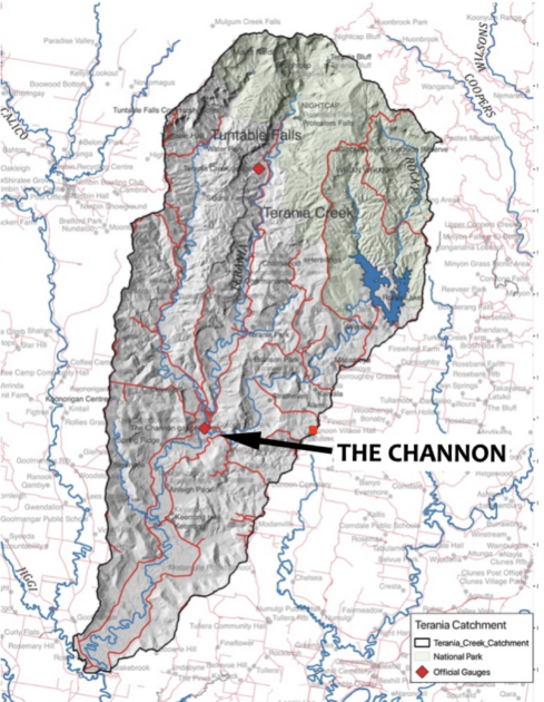
Creek Data
The only creek gauge in the Terania catchment is at the junction of Tuntable and Terania in The Channon. This is too close to be helpful to local people, and is vulnerable to flood damage. Our goal now is to establish creek sentinel locations on headwater creeks. We think a layered creek intel system will be the most resilient and provide redundancies: 1) Basic benchmarked creek locations – easily observed by residents (see photo); 2) One or two sites with flood staff arrays monitored by local people ; 3) Future experimentation may include pressure sensors on Osborne, Whian Whian and possibly Town Rd bridges.
We encourage residents to take photos during floods that include structures that are useful for flood benchmarking. When you find such a spot, take several photos during the event. Your phone will record the time these photos were taken. The more we do this, the more we’ll learn how a volume of rain translates into flood on the ground. building up knowledge of where floods come to on our landscape
We would like to thank Greg Hall for his continued support of our project, and also members of the Institute for Climate, Energy and Disaster Solutions (ANU) who have provided expert support and encouragement. Currently a graduate student is testing potential, affordable electronic creek gauges.
For more information – Annie Kia
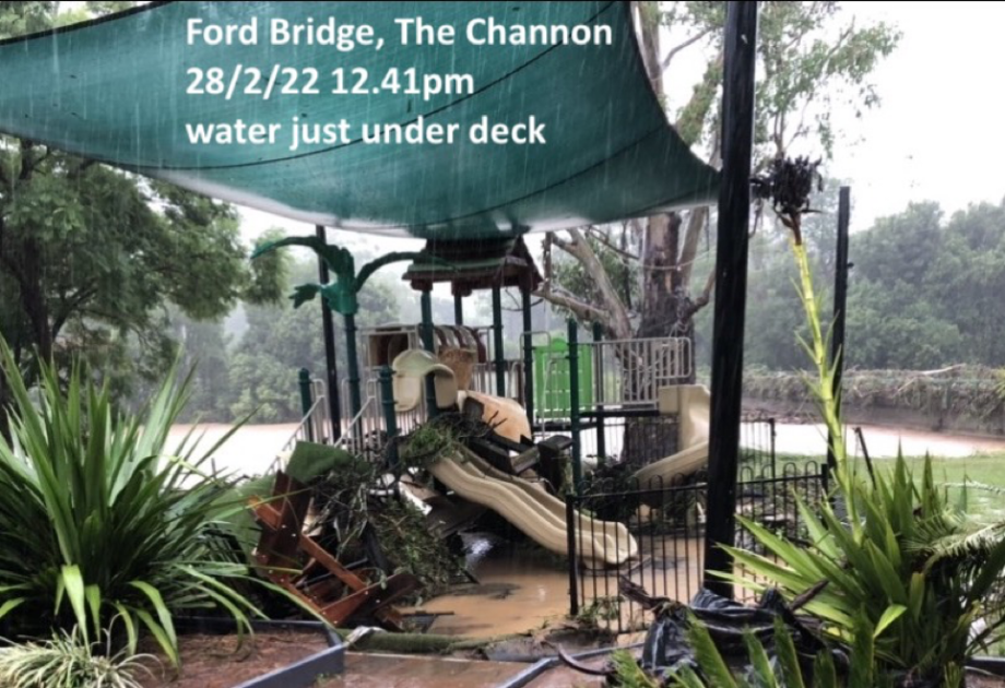
This benchmarking photo is especially useful because the creek gauge ceased working at 2am on 28/2/22. This photo of Ford Bridge gives us an idea of creek levels at 12.41pm that day. When taking photos during flood – look for structures that we can later use to determine flood height at the time you took the photo. If you want to learn how to inscribe photos with benchmarking information (location, date and time) click here.